rmv reference to clearly identified wikipedia mirror per WP:CIRCULAR |
Yamaguchi先生 (talk | contribs) m Reverted edits by 2404:3100:1403:DBD0:9EAA:6EB7:DD39:94CD (talk) to last version by WikiCleanerBot Tag: Rollback |
||
| (40 intermediate revisions by 26 users not shown) | |||
| Line 1: | Line 1: | ||
{{Short description|Capital of Balochistan, Pakistan}} |
{{Short description|Capital of Balochistan, Pakistan}} |
||
{{About|the city|the metric prefix|Quetta-|other uses}} |
{{About|the city|the metric prefix|Quetta-|other uses}} |
||
{{EngvarB|date=January 2019}} |
{{EngvarB|date=January 2019}} |
||
{{Use dmy dates|date=January 2019}} |
{{Use dmy dates|date=January 2019}} |
||
| Line 8: | Line 7: | ||
<!--See the Table at Infobox settlement for all fields and descriptions of usage--> |
<!--See the Table at Infobox settlement for all fields and descriptions of usage--> |
||
<!-- Basic info ---------------->| name = Quetta |
<!-- Basic info ---------------->| name = Quetta |
||
| official_name = |
| official_name = |
||
| other_name = |
| other_name = |
||
| native_name = {{hlist |
| native_name = {{hlist |
||
|{{lang|ps|کوټه}} |
|{{lang|ps|کوټه}} |
||
| Line 16: | Line 15: | ||
}} |
}} |
||
| nickname = ''Fruit Garden of Pakistan'' |
| nickname = ''Fruit Garden of Pakistan'' |
||
| etymology = |
| etymology = |
||
| settlement_type = [[Metropolis]]<!-- Don't change without discussion --> |
| settlement_type = [[Metropolis]]<!-- Don't change without discussion --> |
||
| motto = <!-- images and maps -----------> |
| motto = <!-- images and maps -----------> |
||
| image_skyline = {{multiple image|total_width=280px|perrow=1/2/2/2|border=infobox|caption_align = center |
| image_skyline = {{multiple image|total_width=280px|perrow=1/2/2/2|border=infobox|caption_align = center |
||
| image1 = Quetta cantt.jpg |
| image1 = Quetta cantt.jpg |
||
| caption1 = [[Quetta Cantonment]] |
| caption1 = [[Quetta Cantonment]] |
||
| image2 = Quetta_at_night_2.jpg |
| image2 = Quetta_at_night_2.jpg |
||
| caption2 = Quetta at night |
| caption2 = Quetta at night |
||
| image3 = Quetta Fort Mirri.jpg |
| image3 = Quetta Fort Mirri.jpg |
||
| caption3 = Fort Mirri |
| caption3 = Fort Mirri |
||
| Line 29: | Line 28: | ||
| caption4 = [[Hanna Lake]] |
| caption4 = [[Hanna Lake]] |
||
}} |
}} |
||
| image_flag = |
| image_flag = |
||
| flag_size = |
| flag_size = |
||
| image_seal = |
| image_seal = |
||
| seal_size = |
| seal_size = |
||
| image_shield = |
| image_shield = |
||
| shield_size = |
| shield_size = |
||
| image_blank_emblem = Quetta Metropolitan Corporation.png |
| image_blank_emblem = Quetta Metropolitan Corporation.png |
||
| blank_emblem_type = Emblem |
| blank_emblem_type = Emblem |
||
| blank_emblem_size = 120px |
| blank_emblem_size = 120px |
||
| image_map = |
| image_map = |
||
| |
| map_caption = |
||
| map_caption = |
|||
| pushpin_map = Balochistan Pakistan#Pakistan |
| pushpin_map = Balochistan Pakistan#Pakistan |
||
| ⚫ | |||
| pushpin_label_position = |
|||
| ⚫ | |||
| pushpin_mapsize = <!-- Location ------------------> |
| pushpin_mapsize = <!-- Location ------------------> |
||
| subdivision_type = Country |
| subdivision_type = Country |
||
| Line 53: | Line 50: | ||
| subdivision_type3 = [[Districts of Pakistan|District]] |
| subdivision_type3 = [[Districts of Pakistan|District]] |
||
| subdivision_name3 = [[Quetta District|Quetta]] |
| subdivision_name3 = [[Quetta District|Quetta]] |
||
| ⚫ | |||
<!-- Smaller parts (e.g. boroughs of a city) and seat of government -->| seat_type = |
|||
| seat = |
|||
| parts_type = |
|||
| parts_style = <!--=list (for list), coll (for collapsed list), para (for paragraph format) |
|||
Default is list if up to 5 items, coll if more than 5--> |
|||
| parts = <!-- parts text, or header for parts list --> |
|||
| p1 = |
|||
| p2 = <!-- etc. up to p50: for separate parts to be listed--> |
|||
| ⚫ | |||
| government_type = Municipal Corporation<ref name="Government">{{cite web|url=http://www.balochistan.gov.pk/index.php?option=com_content&view=article&id=836&Itemid=1087|title=Government Organization – Government of Balochistan|work=balochistan.gov.pk|access-date=6 September 2016}}</ref> |
| government_type = Municipal Corporation<ref name="Government">{{cite web|url=http://www.balochistan.gov.pk/index.php?option=com_content&view=article&id=836&Itemid=1087|title=Government Organization – Government of Balochistan|work=balochistan.gov.pk|access-date=6 September 2016}}</ref> |
||
| leader_title = [[Mayor of Quetta|Mayor]] |
| leader_title = [[Mayor of Quetta|Mayor]] |
||
| Line 68: | Line 57: | ||
| leader_name1 = Seat Vacant |
| leader_name1 = Seat Vacant |
||
| leader_title2 = Commissioner |
| leader_title2 = Commissioner |
||
| leader_name2 = |
| leader_name2 = [[Muhammad Hamza Shafqaat|Hamza Shafqaat]]<ref name="dawn1">{{cite news|url=https://www.dawn.com/news/1797418|title=Quetta sit-in continues as talks break down|date=13 December 2023|access-date=19 December 2023|work=Daen (newspaper)}}</ref> |
||
| leader_title3 = [[Deputy Commissioner (Pakistan)|Deputy Commissioner]] |
| leader_title3 = [[Deputy Commissioner (Pakistan)|Deputy Commissioner]] |
||
| leader_name3 = Saad Bin Asad<ref name="dawn1"/> |
|||
| leader_name3 = Shehak Baloch ([[Pakistan Administrative Service|PAS]]) <ref>{{cite news|url=https://tribune.com.pk/story/2395239/atta-crisis-worsens-in-balochistan|title=Atta crisis worsens in Balochistan|date=11 January 2023|access-date=21 January 2023|work=The Express Tribune (newspaper)}}</ref> |
|||
| established_title = Settled |
| established_title = Settled |
||
| established_date = {{start date and age|1876}} |
| established_date = {{start date and age|1876}} |
||
<!-- Area --------------------->| |
<!-- Area --------------------->| unit_pref = PAK |
||
| |
| area_footnotes = |
||
| area_footnotes = |
|||
| area_metro_km2 = 3501 |
| area_metro_km2 = 3501 |
||
| area_total_km2 = 3501 |
| area_total_km2 = 3501 |
||
| area_land_sq_mi = |
|||
| area_water_sq_mi = |
|||
| area_water_percent = <!-- Elevation --------------------------> |
| area_water_percent = <!-- Elevation --------------------------> |
||
| elevation_footnotes = |
| elevation_footnotes = |
||
| elevation_m = 1,680 |
| elevation_m = 1,680 |
||
| elevation_ft = 5,510 |
| elevation_ft = 5,510 |
||
| elevation_max_m = |
| elevation_max_m = |
||
| ⚫ | |||
| elevation_max_ft = |
|||
| elevation_min_m = |
|||
| ⚫ | |||
| population_as_of = [[2017 Census of Pakistan|2017]] |
| population_as_of = [[2017 Census of Pakistan|2017]] |
||
| population_footnotes = <ref name="census2017">{{cite report|year=2017|title=DISTRICT WISE CENSUS RESULTS CENSUS 2017|url=http://www.pbscensus.gov.pk/sites/default/files/DISTRICT_WISE_CENSUS_RESULTS_CENSUS_2017.pdf|archive-url=https://web.archive.org/web/20170829164748/http://www.pbscensus.gov.pk/sites/default/files/DISTRICT_WISE_CENSUS_RESULTS_CENSUS_2017.pdf|archive-date=2017-08-29|publisher=Pakistan Bureau of Statistics|page=13|access-date=29 March 2018}}</ref> |
| population_footnotes = <ref name="census2017">{{cite report|year=2017|title=DISTRICT WISE CENSUS RESULTS CENSUS 2017|url=http://www.pbscensus.gov.pk/sites/default/files/DISTRICT_WISE_CENSUS_RESULTS_CENSUS_2017.pdf|archive-url=https://web.archive.org/web/20170829164748/http://www.pbscensus.gov.pk/sites/default/files/DISTRICT_WISE_CENSUS_RESULTS_CENSUS_2017.pdf|archive-date=2017-08-29|publisher=Pakistan Bureau of Statistics|page=13|access-date=29 March 2018}}</ref> |
||
| population_note = |
| population_note = |
||
| total_type = [[City]] |
| total_type = [[City]] |
||
| population_total = 1,001,205 |
| population_total = 1,001,205 |
||
| Line 99: | Line 83: | ||
<!-- General information --------------->| timezone = [[Pakistan Standard Time|PKT]] |
<!-- General information --------------->| timezone = [[Pakistan Standard Time|PKT]] |
||
| utc_offset = +05:00 |
| utc_offset = +05:00 |
||
| timezone_DST = |
| timezone_DST = |
||
| utc_offset_DST = |
| utc_offset_DST = |
||
| coordinates = {{coord|30|11|N|67|00|E|region:PK|display=inline,title}} |
| coordinates = {{coord|30|11|N|67|00|E|region:PK|display=inline,title}} |
||
| postal_code_type = [[Postal codes in Pakistan|Postal code]] |
| postal_code_type = [[Postal codes in Pakistan|Postal code]] |
||
| Line 109: | Line 93: | ||
}} |
}} |
||
'''Quetta''' ({{IPAc-en|'|k|w|ɛ|t|ə}}; {{lang-ur|{{Nastaliq|کوئٹہ}}}} |
'''Quetta''' ({{IPAc-en|'|k|w|ɛ|t|ə}}; {{lang-ur|{{Nastaliq|کوئٹہ}}}}, ''ko'eṭa'', {{IPA-hns|ˈkweːʈə||Quetta pronunciation.ogg}} {{Lang-bal|کویٹہ}}, {{Lang-ps|کوټه}}) is the capital and largest city of the [[Administrative units of Pakistan|Pakistani province]] of [[Balochistan, Pakistan|Balochistan]]. It is the tenth [[List of cities in Pakistan by population|largest city]] in [[Pakistan]], with a population of over 1.6 million.<ref>{{cite web |title=Quetta Population 2024 |url=https://worldpopulationreview.com/world-cities/quetta-population |website=worldpopulationreview.com}}</ref> It is situated in the south-west of the country, lying in a valley surrounded by mountains on all sides. Quetta is at an average elevation of {{convert|1680|m|ft|abbr=off}} above sea level,<ref>{{cite web |url=http://population.mongabay.com/population/pakistan/1167528/quetta|title=Mongabay -environmental science and conservation news|url-status=dead |archive-url=https://web.archive.org/web/20160304052058/http://population.mongabay.com/population/pakistan/1167528/quetta |archive-date=4 March 2016 }}</ref> making it Pakistan's highest altitude major city. The city is known as the ''"Fruit Garden of Pakistan"'' due to the numerous fruit orchards in and around it and the large variety of fresh and dried fruits produced there.<ref name="Quetta fruit garden of Pakistan">{{cite news|url=https://www.bolnews.com/trending/2020/01/winter-destinations-mesmerizing-places-in-pakistan/|title= Winter destinations – Mesmerizing places in Pakistan |work=[[Bol News]]|date=18 January 2020 |access-date=7 January 2022}}</ref> |
||
Quetta is a multi ethnic city with [[Pashtuns]], [[Baloch people|Balochs]], [[Hazara people|Hazaras]], [[Brahui people|Brahui]], [[Punjabi people|Punjabis]] and other settlers from around the country living peacefully together with mutual trust as well respect for the 3% religious minority living in the city. |
|||
| ⚫ | Located in |
||
| ⚫ | Located in northern [[Balochistan]] near the [[Durand line|Pakistan-Afghanistan border]] and the road across to [[Kandahar]], Quetta is a trade and communication centre between the two countries.<ref>{{cite journal |last1=Gazdar |first1=Haris |last2=Kaker |first2=Sobia Ahmad |last3=Khan |first3=Irfan |title=Buffer zone, colonial enclave or urban hub? Quetta: between four regions and two wars |journal=www.crisisstates.com |date=February 2010 |url=https://eprints.lse.ac.uk/28472/ |language=en}}</ref> The city is near the [[Bolan Pass]], which was on a major gateway from [[Central Asia]] to [[South Asia]]. Quetta is currently home to 500,000 undocumented Afghan refugees.{{Citation needed|date=August 2023}} |
||
== Etymology == |
== Etymology == |
||
| Line 118: | Line 104: | ||
== History == |
== History == |
||
{{See also|History of Quetta}} |
{{See also|History of Quetta}} |
||
<gallery mode="packed" widths="200"> |
|||
File:Quetta Fort Mirri.jpg|Quetta Fort Mirri |
|||
File:Quetta 1880.JPG|Fort Mirri in 1880 |
|||
File:Quetta4m.jpg|Quetta Cantonment, 1889 |
|||
</gallery> |
|||
The immediate area has long been one of pastures and mountains, with varied [[plants]] and animals relative to the dry plains to the west. |
The immediate area has long been one of pastures and mountains, with varied [[plants]] and animals relative to the dry plains to the west. |
||
| Line 157: | Line 147: | ||
|2017 |1001205 |
|2017 |1001205 |
||
}} |
}} |
||
The population of the city is around one million. In 2016, it was estimated at 1,140,000,<ref name="pop_est">{{cite web|url=http://www.demographia.com/db-worldua.pdf |archive-url=https://web.archive.org/web/20040330085700/http://www.demographia.com/db-worldua.pdf |archive-date=2004-03-30 |url-status=live |title=Demographics |publisher=www.demographia.com |date= |access-date=2020-03-16}}</ref> but the 2017 Census revealed a total of 1,001,205.{{Citation needed|date=August 2023}} This makes it the largest city in Balochistan province and one of the major cities of Pakistan. The scholars disagree about the demographics of the city. According to some, the city has a [[Pashtuns|Pashtun]] plurality followed by Baloch people. The Hazaras and the settlers from other areas of Pakistan also live here.{{sfn|Jonah Blank|Christopher Clary|Brian Nichiporuk|2014}} |
The population of the city is around one million. In 2016, it was estimated at 1,140,000,<ref name="pop_est">{{cite web|url=http://www.demographia.com/db-worldua.pdf |archive-url=https://web.archive.org/web/20040330085700/http://www.demographia.com/db-worldua.pdf |archive-date=2004-03-30 |url-status=live |title=Demographics |publisher=www.demographia.com |date= |access-date=2020-03-16}}</ref> but the 2017 Census revealed a total of 1,001,205.{{Citation needed|date=August 2023}} This makes it the largest city in Balochistan province and one of the major cities of Pakistan. The scholars disagree about the demographics of the city. According to some, the city has a [[Pashtuns|Pashtun]] plurality followed by Baloch people. The Hazaras and the settlers from other areas of Pakistan also live here.{{sfn|Jonah Blank|Christopher Clary|Brian Nichiporuk|2014}}<ref name="Paksitan & The Karakoram Highway">{{cite book|author=Sarina Singh|title=Pakistan & the Karakoram Highway|url=https://books.google.com/books?id=zn8I4qEew9oC&pg=PA142|year=2008|publisher=Lonely Planet|isbn=978-1-74104-542-0|page=142}}</ref><ref name="The Pashtun Question">{{cite book|author=Abubakar Siddique|title=The Pashtun Question: The Unresolved Key to the Future of Pakistan and Afghanistan|url=https://books.google.com/books?id=PkVeBAAAQBAJ&pg=PA22|year=2014|publisher=Hurst|isbn=978-1-84904-292-5|page=22}}</ref> [[Urdu]] being the national language is used and understood by all the residents and serves as a [[lingua franca]]. |
||
According to [[Reuters]] and the [[BBC]], there are as many as 500,000-600,000 [[Hazaras]] living in Quetta and its surrounding areas.<ref>{{Cite news | url=https://www.reuters.com/article/us-pakistan-shooting/two-killed-in-sectarian-attack-in-southwestern-pakistan-idUSKBN1HT0N2 | title=Two killed in sectarian attack in southwestern Pakistan| work=Reuters| date=22 April 2018}}</ref><ref>{{cite news | url=https://www.bbc.co.uk/news/world-asia-42219669| title=The community caged in its own city|work=BBC News| date=12 December 2017| last1=Kermani| first1=Secunder |author-link1=Secunder Kermani}}</ref> |
According to [[Reuters]] and the [[BBC]], there are as many as 500,000-600,000 [[Hazaras]] living in Quetta and its surrounding areas.<ref>{{Cite news | url=https://www.reuters.com/article/us-pakistan-shooting/two-killed-in-sectarian-attack-in-southwestern-pakistan-idUSKBN1HT0N2 | title=Two killed in sectarian attack in southwestern Pakistan| work=Reuters| date=22 April 2018}}</ref><ref>{{cite news | url=https://www.bbc.co.uk/news/world-asia-42219669| title=The community caged in its own city|work=BBC News| date=12 December 2017| last1=Kermani| first1=Secunder |author-link1=Secunder Kermani}}</ref> |
||
| Line 256: | Line 246: | ||
* [[Balochistan University of Information Technology Engineering and Management Sciences|Balochistan University of Information Technology, Engineering and Management Sciences]] (BUITEMS) |
* [[Balochistan University of Information Technology Engineering and Management Sciences|Balochistan University of Information Technology, Engineering and Management Sciences]] (BUITEMS) |
||
* [[Bolan Medical College]] |
* [[Bolan Medical College]] |
||
* Islamia High School: It was frequently visited by [[Quaid-e-Azam]] in 1937 and was nicknamed as ''Chhota Aligarh'' (Little [[Aligarh Muslim University|Aligarh]]) by him<ref>{{cite web |url=http://www.nihcr.edu.pk/Latest_English_Journal/Pjhc%252029-1%25202008/4-Balochistan%2520ML%2520J%2520Haider.pdf&ved=0ahUKEwj2sprSqKvLAhVBEJAKHU8OBdI4ChAWCBwwAQ&usg=AFQjCNF5kpYY9bzYNkFrV-HL9qj2Ve4A_Q&sig2=h2kfFISYJNVuGy8QWok8ZQ |title=The Balochistan Muslim League|website=National Institute of Historical & Cultural Research – Pakistan|author=Javed Haider Sayed|access-date=6 March 2016|year=2008|location=Quaid-e-Azam University, Islamabad}}{{dead link|date=April 2018 |bot=InternetArchiveBot |fix-attempted=yes }}</ref> |
* [[Islamia High School, Quetta]]: It was frequently visited by [[Quaid-e-Azam]] in 1937 and was nicknamed as ''Chhota Aligarh'' (Little [[Aligarh Muslim University|Aligarh]]) by him<ref>{{cite web |url=http://www.nihcr.edu.pk/Latest_English_Journal/Pjhc%252029-1%25202008/4-Balochistan%2520ML%2520J%2520Haider.pdf&ved=0ahUKEwj2sprSqKvLAhVBEJAKHU8OBdI4ChAWCBwwAQ&usg=AFQjCNF5kpYY9bzYNkFrV-HL9qj2Ve4A_Q&sig2=h2kfFISYJNVuGy8QWok8ZQ |title=The Balochistan Muslim League|website=National Institute of Historical & Cultural Research – Pakistan|author=Javed Haider Sayed|access-date=6 March 2016|year=2008|location=Quaid-e-Azam University, Islamabad}}{{dead link|date=April 2018 |bot=InternetArchiveBot |fix-attempted=yes }}</ref> |
||
* [[Pakistan Command and Staff College]] |
* [[Pakistan Command and Staff College]] |
||
* [[Sardar Bahadur Khan Women's University]] |
* [[Sardar Bahadur Khan Women's University]] |
||
* [[St Francis Grammar School]] |
* [[St Francis Grammar School]] |
||
* [[St. Joseph's Convent School, Quetta]] |
* [[St. Joseph's Convent School, Quetta]] |
||
| ⚫ | |||
* [[Tameer-e-Nau Public College, Quetta|Tameer-e-Nau Public College]] |
* [[Tameer-e-Nau Public College, Quetta|Tameer-e-Nau Public College]] |
||
* [[University Law College]] |
* [[University Law College, Quetta]] |
||
* [[University of Balochistan]] |
* [[University of Balochistan]] |
||
{{Cleanup-list|section|date=April 2023}} |
|||
* [[National University Of Science And Technology NUST Quetta Campus]] |
|||
* [[OPF Public School]] |
|||
* [[Pakistan School of Infantry and Tactics]] |
|||
* [[Quetta Institute of Medical Sciences]] |
|||
| ⚫ | |||
* Degree college, Quetta. |
|||
== Media == |
|||
{{expand section|date=January 2023}} |
|||
=== Television === |
|||
* [[Mechid TV]], a private television channel of the [[Hazaras]].{{cn}} |
|||
== Sports == |
== Sports == |
||
[[File:Qayyum Changezi.jpg|thumb|200x200px|The [[Qayyum Papa Stadium]] is named after [[Pakistan national football team]] captain [[Qayyum Changezi]], hailing from Quetta]] |
|||
[[association football|Football]] is the most popular sport among the people of Quetta. Football clubs from Quetta include: Quetta Zorawar, [[Muslim FC]], [[Balochistan United W.F.C.]], Hazara Green Football Club, Baluch Football Club and Quetta Bazigars Club. Balochistan United W.F.C. won the [[2014 National Women Football Championship|2014 National Women Championship]]. |
|||
[[association football|Football]] is the most popular sport among the people of Quetta.<ref>{{Cite web |last=Raheel |first=Natasha |date=2021-12-05 |title=Football, Balochistan and hope |url=https://tribune.com.pk/story/2332579/football-balochistan-and-hope |access-date=2024-05-11 |website=The Express Tribune |language=en}}</ref><ref>{{Cite web |last=Wasim |first=Umaid |date=2021-11-26 |title=Balochistan’s boundless passion for football has nowhere to go but an event is keeping the flame alive |url=https://www.dawn.com/news/1660239 |access-date=2024-05-30 |website=DAWN.COM |language=en}}</ref> The city has produced notable footballers for the [[Pakistan national football team]] including [[Abdul Wahid Durrani]], [[Qayyum Changezi]], [[Ayub Dar]], [[Mohammad Ali (footballer, born 1989)|Mohammad Ali]], and [[Rajab Ali (footballer)|Rajab Ali Hazara]].<ref>{{Cite web |last=InpaperMagazine |first=From |date=2013-01-13 |title=In-depth: Pakistan football |url=https://www.dawn.com/2013/01/13/in-depth-pakistan-football/ |access-date=2024-05-05 |website=DAWN.COM |language=en}}</ref> Main football clubs from Quetta include [[Baloch FC Quetta|Baloch Quetta]] and now defunct Quetta Zorawar. [[Balochistan United W.F.C.|Balochistan United WFC]] won the [[2014 National Women Football Championship|2014 National Women Championship]]. The major football ground is [[Ayub National Stadium]], a multipurpose stadium also used for athletics. Other football grounds include [[Qayyum Papa Stadium]] and [[Sadiq Shaheed Stadium]]. |
|||
[[File:Bugti stadium Quetta.jpg|thumb|alt=Quetta cricket stadium| |
[[File:Bugti stadium Quetta.jpg|thumb|alt=Quetta cricket stadium|[[Bugti Stadium]], home of Quetta Gladiators|left]] |
||
[[Bugti Stadium]] is the home of [[Balochistan cricket team]], a [[first-class cricket]] team which competes in domestic tournaments,<ref name=Cricinfo1>{{cite web|url=https://www.espncricinfo.com/story/_/id/27504448/pcb-unveils-new-domestic-set-stay-top-mantra |title=PCB unveils new domestic set-up with 'stay at the top' mantra |work=ESPN Cricinfo}}</ref> and the Quetta based team [[Quetta Gladiators]] compete in the [[Pakistan Super League]] (PSL). They were the champion of the [[2019 Pakistan Super League|PSL 2019]]. |
[[Bugti Stadium]] is the home of [[Balochistan cricket team]], a [[first-class cricket]] team which competes in domestic tournaments,<ref name=Cricinfo1>{{cite web|url=https://www.espncricinfo.com/story/_/id/27504448/pcb-unveils-new-domestic-set-stay-top-mantra |title=PCB unveils new domestic set-up with 'stay at the top' mantra |work=ESPN Cricinfo}}</ref> and the Quetta based team [[Quetta Gladiators]] compete in the [[Pakistan Super League]] (PSL). They were the champion of the [[2019 Pakistan Super League|PSL 2019]]. |
||
| Line 287: | Line 266: | ||
=== Facilities === |
=== Facilities === |
||
| ⚫ | [[File:Musa sports stadium, Quetta.jpg|thumb|Musa Sports Complex]]Local facilities were created in the city for [[mountain climbing]] and [[caving]] as well as water sports. [[Hayatullah Khan Durrani]] ([[Pride of Performance]]) is the chief executive of Hayat Durrani Water Sports Academy, Balochistan's first and only Rowing, Canoeing, Kayaking, Sailing, rough swimming and boating academy where all such facilities provide free to the youth members at [[Hanna Lake]]. |
||
[[File:Musa sports stadium, Quetta.jpg|thumb|Musa Sports Complex]] |
|||
The Shaheed Nauoroz Stadium is the largest stadium in the city. The city also has [[Ayub National Stadium]], a multipurpose stadium used for football and cricket and [[Bugti Stadium]] for cricket. |
|||
| ⚫ | Local facilities were created in the city for [[mountain climbing]] and [[caving]] as well as water sports. [[Hayatullah Khan Durrani]] ([[Pride of Performance]]) is the chief executive of Hayat Durrani Water Sports Academy, Balochistan's first and only Rowing, Canoeing, Kayaking, Sailing, rough swimming and boating academy where all such facilities provide free to the youth members at [[Hanna Lake]]. |
||
== Twin towns and sister cities == |
== Twin towns and sister cities == |
||
{{Main|List of twin towns and sister cities in Pakistan}} |
{{Main|List of twin towns and sister cities in Pakistan}} |
||
==Gallery== |
|||
<gallery widths="180"> |
|||
File:Quetta Infantry School.png|Junior officers in a tactical discussion at the Infantry School, Quetta |
|||
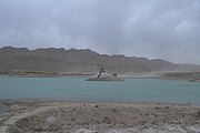
File:Hanna Lake Quetta P1140271.jpg|[[Hanna Lake]] |
|||
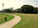
File:Askrri park quetta - panoramio.jpg|Askari Park |
|||
File:Jinnah Road, Quetta.JPG|Jinnah Road |
|||
File:Quetta1880---.JPG|Quetta in 1880 |
|||
</gallery> |
|||
== See also == |
== See also == |
||
Latest revision as of 14:47, 24 June 2024
Quetta
| |
|---|---|
 Emblem | |
| Nickname: Fruit Garden of Pakistan | |
 Quetta  Quetta | |
| Coordinates: 30°11′N 67°00′E / 30.183°N 67.000°E | |
| Country | |
| Province | |
| Division | Quetta |
| District | Quetta |
| Settled | 1876 |
| Government | |
| • Type | Municipal Corporation[1] |
| • Mayor | Seat Vacant |
| • Deputy Mayor | Seat Vacant |
| • Commissioner | Hamza Shafqaat[2] |
| • Deputy Commissioner | Saad Bin Asad[2] |
| Area | |
| • City | 3,501 km2 (1,352 sq mi) |
| • Metro | 3,501 km2 (1,352 sq mi) |
| Elevation | 1,680 m (5,510 ft) |
| Population | |
| • City | 1,001,205 |
| • Rank | 10th in Pakistan; 1st in Balochistan |
| • Density | 290/km2 (740/sq mi) |
| • Demonym | Quettan or Quettawal (kʰwətə.wal) |
| Time zone | UTC+05:00 (PKT) |
| Postal code | 87300 |
| Dialing code | 081 |
| Website | www |


Quetta (/ˈkwɛtə/; Urdu: کوئٹہ, ko'eṭa, [ˈkweːʈə] Balochi: کویٹہ, Pashto: کوټه) is the capital and largest city of the Pakistani province of Balochistan. It is the tenth largest city in Pakistan, with a population of over 1.6 million.[4] It is situated in the south-west of the country, lying in a valley surrounded by mountains on all sides. Quetta is at an average elevation of 1,680 metres (5,510 feet) above sea level,[5] making it Pakistan's highest altitude major city. The city is known as the "Fruit Garden of Pakistan" due to the numerous fruit orchards in and around it and the large variety of fresh and dried fruits produced there.[6]
Quetta is a multi ethnic city with Pashtuns, Balochs, Hazaras, Brahui, Punjabis and other settlers from around the country living peacefully together with mutual trust as well respect for the 3% religious minority living in the city.
Located in northern Balochistan near the Pakistan-Afghanistan border and the road across to Kandahar, Quetta is a trade and communication centre between the two countries.[7] The city is near the Bolan Pass, which was on a major gateway from Central Asia to South Asia. Quetta is currently home to 500,000 undocumented Afghan refugees.[citation needed]
Etymology
The name Quetta is a variation of the Pashto word Kwatkōṭ, or kōta meaning "fortress".[8] Quetta was formerly known as Shalkot (Pashto: ښالکوټ; Balochi: شال کوٹ),[9]
History
-
 Quetta Fort Mirri
 -
 Fort Mirri in 1880
 -
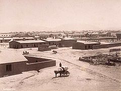 Quetta Cantonment, 1889


The immediate area has long been one of pastures and mountains, with varied plants and animals relative to the dry plains to the west.
From 11th century, the land of Quetta was owned and ruled by the Kasi Pashtun tribe. It was captured by Sultan Mahmud Ghaznavi during his invasion of South Asia.[10] In 1543, Mughal emperor Humayun came to Quetta en route to Safavid Persia, leaving his son and future Mughal emperor Akbar here. In 1709, the region was a part of Afghan Hotak dynasty and stayed a part until 1747 when Ahmed Shah Durrani conquered it and made it a part of Durrani Empire. The first European visited Quetta in 1828, describing it as mud-walled fort surrounded by three hundred mud houses.[11]
In 1876, Quetta was occupied by the British and subsequently incorporated into British India.[10] In 1856, British General John Jacob had urged his government to occupy Quetta given its strategic position on the western frontier.[12] British troops constructed the infrastructure for their establishment.

By the time of the earthquake on 31 May 1935, Quetta had developed into a bustling city with a number of skyscraper buildings and so was known as "Little London".[citation needed] The epicentre of the earthquake was close to the city and destroyed most of the city's infrastructure, killing an estimated 40,000 people.[13]
Geography
Climate
Quetta has a cold semi-arid climate (Köppen BSk) with a significant variation between summer and winter temperatures. Summer starts from late May and goes on until early September with average temperatures ranging from 24–26 °C (75–79 °F). The highest temperature in Quetta is 42 °C (108 °F) which was recorded on 10 July 1998.[14] Autumn starts in mid-September and continues until mid-November with average temperatures in the 12–18 °C (54–64 °F) range. Winter starts in late November and ends in late February with average temperatures near 4–5 °C (39–41 °F). The lowest temperature in Quetta is −18.3 °C (−0.9 °F) which was recorded on 8 January 1970.[14] Spring starts in early March and ends in mid-May with average temperatures close to 15 °C (59 °F). Unlike more easterly parts of Pakistan, Quetta does not have a monsoon season of heavy rainfall. Highest rainfall during 24 hours in Quetta is 113 millimetres (4.4 in) which was recorded on 17 December 2000,[14] Highest monthly rainfall of 232.4 millimetres (9.15 in) was recorded in March 1982 which was also the year of the highest annual rainfall, 949.8 millimetres (37.39 in).[14] In the winter, snowfall has become quite erratic (December, January and February).
| Climate data for Quetta (1991-2020) | |||||||||||||
|---|---|---|---|---|---|---|---|---|---|---|---|---|---|
| Month | Jan | Feb | Mar | Apr | May | Jun | Jul | Aug | Sep | Oct | Nov | Dec | Year |
| Record high °C (°F) | 23.6 (74.5) |
26.7 (80.1) |
31.1 (88.0) |
35.0 (95.0) |
39.4 (102.9) |
41.5 (106.7) |
42.0 (107.6) |
40.6 (105.1) |
38.3 (100.9) |
34.0 (93.2) |
36.0 (96.8) |
25.0 (77.0) |
42.0 (107.6) |
| Mean daily maximum °C (°F) | 11.8 (53.2) |
14.0 (57.2) |
19.5 (67.1) |
25.9 (78.6) |
31.4 (88.5) |
35.5 (95.9) |
36.8 (98.2) |
35.4 (95.7) |
31.9 (89.4) |
26.0 (78.8) |
19.6 (67.3) |
14.6 (58.3) |
25.2 (77.4) |
| Daily mean °C (°F) | 4.8 (40.6) |
7.1 (44.8) |
12.5 (54.5) |
17.9 (64.2) |
23.0 (73.4) |
27.3 (81.1) |
29.2 (84.6) |
27.5 (81.5) |
22.8 (73.0) |
16.5 (61.7) |
11.0 (51.8) |
6.5 (43.7) |
17.2 (62.9) |
| Mean daily minimum °C (°F) | −1.9 (28.6) |
0.3 (32.5) |
5.1 (41.2) |
10.0 (50.0) |
14.6 (58.3) |
19.0 (66.2) |
21.6 (70.9) |
19.7 (67.5) |
13.6 (56.5) |
7.0 (44.6) |
1.9 (35.4) |
−1.4 (29.5) |
9.1 (48.4) |
| Record low °C (°F) | −18.3 (−0.9) |
−16.7 (1.9) |
−8.3 (17.1) |
−3.9 (25.0) |
−0.3 (31.5) |
5.0 (41.0) |
8.9 (48.0) |
3.3 (37.9) |
−0.6 (30.9) |
−8.3 (17.1) |
−13.3 (8.1) |
−18.3 (−0.9) |
−18.3 (−0.9) |
| Average precipitation mm (inches) | 55.0 (2.17) |
58.4 (2.30) |
49.5 (1.95) |
40.0 (1.57) |
17.8 (0.70) |
3.2 (0.13) |
8.8 (0.35) |
4.9 (0.19) |
4.2 (0.17) |
4.5 (0.18) |
19.3 (0.76) |
34.6 (1.36) |
300.2 (11.83) |
| Average snowfall cm (inches) | 22 (8.7) |
17 (6.6) |
3.0 (1.2) |
0 (0) |
0 (0) |
0 (0) |
0 (0) |
0 (0) |
0 (0) |
0 (0) |
0.51 (0.2) |
14 (5.4) |
56.51 (22.1) |
| Average precipitation days (≥ 1.0 mm) | 5.0 | 5.7 | 5.4 | 4.1 | 1.7 | 0.7 | 0.8 | 0.8 | 0.4 | 0.6 | 1.7 | 2.7 | 29.6 |
| Mean monthly sunshine hours | 220.1 | 209.05 | 232.5 | 273.0 | 334.8 | 327.0 | 313.1 | 313.1 | 294.0 | 306.9 | 279.0 | 238.7 | 3,341.25 |
| Source 1: NOAA,[15] Hong Kong Observatory (altitude: 1589 m) (only snow inch, sun)[16] | |||||||||||||
| Source 2: PMD[17] | |||||||||||||
The city saw a severe drought from 1999 to 2001 during which the city did not receive snowfall and below normal rains. In 2002, the city received snow after a gap of five years. In 2004 and 2005, the city received normal rains after three years without snowfall while in 2006, 2007 and 2009 the city received no snow. In 2008, it received a snowfall of 10 centimetres (4 in) in four hours on 29 January,[18] followed on 2 February by 25.4 centimetres (10 in) in 10 hours[19] – the city's heaviest snowfall in a decade. During the winter of 2010, it received no snow and saw below normal rains due to the presence of El-Nino over Pakistan.[citation needed]
Demographics
| Year | Pop. | ±% |
|---|---|---|
| 1941 | 65,000 | — |
| 1951 | 84,000 | +29.2% |
| 1961 | 107,000 | +27.4% |
| 1972 | 158,000 | +47.7% |
| 1981 | 286,000 | +81.0% |
| 1998 | 565,137 | +97.6% |
| 2017 | 1,001,205 | +77.2% |
| Source: [20][3] | ||
The population of the city is around one million. In 2016, it was estimated at 1,140,000,[21] but the 2017 Census revealed a total of 1,001,205.[citation needed] This makes it the largest city in Balochistan province and one of the major cities of Pakistan. The scholars disagree about the demographics of the city. According to some, the city has a Pashtun plurality followed by Baloch people. The Hazaras and the settlers from other areas of Pakistan also live here.[22][23][24] Urdu being the national language is used and understood by all the residents and serves as a lingua franca.
According to Reuters and the BBC, there are as many as 500,000-600,000 Hazaras living in Quetta and its surrounding areas.[25][26]
| Religious group |
1941[27]: 13–14 | 2017[28][29] | ||
|---|---|---|---|---|
| Pop. | % | Pop. | % | |
| Islam |
27,935 | 43.33% | 975,815 | 97.64% |
| Hinduism |
24,010 | 37.24% | 6,112 | 0.61% |
| Sikhism |
7,364 | 11.42% | — | — |
| Christianity |
5,024 | 7.79% | 16,842 | 1.69% |
| Zoroastrianism |
73 | 0.11% | — | — |
| Buddhism |
42 | 0.07% | — | — |
| Judaism |
11 | 0.02% | — | — |
| Jainism |
6 | 0.01% | — | — |
| Ahmadiyya |
— | — | 363 | 0.04% |
| Others | 11 | 0.02% | 253 | 0.03% |
| Total population | 64,476 | 100% | 999,385 | 100% |
Administration
At the local level, the city is governed by a municipal corporation consisting of 66 ward members which elects a mayor and a deputy mayor.[1] In addition, Quetta Development Authority is responsible for provision of municipal services for the city.[30]
Transportation


Quetta is on the western side of Pakistan and is connected to the rest of the country by a network of roads, railways and its international airport close to its centre.
At an altitude of 1,605 metres (5,266 feet) above sea level, Quetta International Airport is the second highest airport in Pakistan.[31] Pakistan International Airlines has regular flights to and from the other major cities of Pakistan including Islamabad, Gwadar, Karachi, Lahore and Peshawar.
Quetta Railway Station is one of the highest railway stations in Pakistan at 1,676 metres (5,499 feet) above sea level. The railway track was laid in the 1890s during the British era to link Quetta with rest of the country. The extensive network of Pakistan Railways connects Quetta to Karachi in the south, by a 863 km (536 mi) track, Lahore in the northeast (1,170 km or 727 miles) and Peshawar further northeast (1,587 km or 986 miles). A metalled road runs alongside the railway that connects Quetta to Karachi via the nearby town of Sibi to Jacobabad and Rohri in the plain of the River Indus.[32]
Education
Quetta serves as the learning centre for the Balochistan province. The city has a number of government and private colleges, including the following:
- Balochistan Agriculture College
- Balochistan University of Information Technology, Engineering and Management Sciences (BUITEMS)
- Bolan Medical College
- Islamia High School, Quetta: It was frequently visited by Quaid-e-Azam in 1937 and was nicknamed as Chhota Aligarh (Little Aligarh) by him[33]
- Pakistan Command and Staff College
- Sardar Bahadur Khan Women's University
- St Francis Grammar School
- St. Joseph's Convent School, Quetta
- Government Science College, Quetta
- Tameer-e-Nau Public College
- University Law College, Quetta
- University of Balochistan
Sports

Football is the most popular sport among the people of Quetta.[34][35] The city has produced notable footballers for the Pakistan national football team including Abdul Wahid Durrani, Qayyum Changezi, Ayub Dar, Mohammad Ali, and Rajab Ali Hazara.[36] Main football clubs from Quetta include Baloch Quetta and now defunct Quetta Zorawar. Balochistan United WFC won the 2014 National Women Championship. The major football ground is Ayub National Stadium, a multipurpose stadium also used for athletics. Other football grounds include Qayyum Papa Stadium and Sadiq Shaheed Stadium.

Bugti Stadium is the home of Balochistan cricket team, a first-class cricket team which competes in domestic tournaments,[37] and the Quetta based team Quetta Gladiators compete in the Pakistan Super League (PSL). They were the champion of the PSL 2019.
Boxing is highly popular as well.[38] Muhammad Waseem is a professional boxer from Quetta. In Body Building Nisar Ahmed Khilji has Mr. Balochistan and Mr. Pakistan Titles and Pakistan representation in International Body Building Contests. In hockey, Quetta has produced Zeeshan Ashraf and Shakeel Abbasi, who were members of the Pakistan's national hockey team.
Facilities

Local facilities were created in the city for mountain climbing and caving as well as water sports. Hayatullah Khan Durrani (Pride of Performance) is the chief executive of Hayat Durrani Water Sports Academy, Balochistan's first and only Rowing, Canoeing, Kayaking, Sailing, rough swimming and boating academy where all such facilities provide free to the youth members at Hanna Lake.
Twin towns and sister cities
Gallery
-
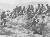 Junior officers in a tactical discussion at the Infantry School, Quetta
 -
-
 Askari Park
 -
 Jinnah Road
 -
 Quetta in 1880


See also
- 2008 Ziarat earthquake
- List of people from Quetta
- Balochi cuisine
- Quetta hut
- RMS Quetta
- Quetta Memorial Precinct
- Governor's House, Quetta
Notes
References
- ^ a b "Government Organization – Government of Balochistan". balochistan.gov.pk. Retrieved 6 September 2016.
- ^ a b "Quetta sit-in continues as talks break down". Daen (newspaper). 13 December 2023. Retrieved 19 December 2023.
- ^ a b DISTRICT WISE CENSUS RESULTS CENSUS 2017 (PDF) (Report). Pakistan Bureau of Statistics. 2017. p. 13. Archived from the original (PDF) on 29 August 2017. Retrieved 29 March 2018.
- ^ "Quetta Population 2024". worldpopulationreview.com.
- ^ "Mongabay -environmental science and conservation news". Archived from the original on 4 March 2016.
- ^ "Winter destinations – Mesmerizing places in Pakistan". Bol News. 18 January 2020. Retrieved 7 January 2022.
- ^ Gazdar, Haris; Kaker, Sobia Ahmad; Khan, Irfan (February 2010). "Buffer zone, colonial enclave or urban hub? Quetta: between four regions and two wars". www.crisisstates.com.
- ^ Everett-Heath, John (24 October 2019), "Quetta", The Concise Oxford Dictionary of World Place Names, Oxford University Press, doi:10.1093/acref/9780191882913.001.0001, ISBN 978-0-19-188291-3, retrieved 4 September 2021
- ^ Thornton, Thomas Henry (1895). Colonel Sir Robert Sandeman: His Life and Work on Our Indian Frontier. A Memoir, with Selections from His Correspondence and Official Writings. J. Murray.
- ^ a b Burki, Shahid Javed (2015). Historical Dictionary of Pakistan. Rowman & Littlefield. ISBN 9781442241480.
- ^ "History of District". bhc.gov.pk. Retrieved 26 November 2017.
- ^ Dodwell, H. H. (1929). The Cambridge History of the British Empire. CUP Archive.
- ^ ڈان اردو (30 December 2013). "پاکستانی شہروں کی تاریخ". dawnnews.tv. Retrieved 26 February 2016.
- ^ a b c d "Mean FOR THE PERIOD 1961 – 2009". Karachi: Climate Data Processing Centre (CDPC), Pakistan Meteorological Department. Archived from the original on 13 June 2010.
- ^ "Quetta Climate Normals 1991–2020". World Meteorological Organization Climatological Standard Normals (1991–2020). National Oceanic and Atmospheric Administration. Retrieved 17 September 2023.
- ^ "Climatological Information for Quetta, Pakistan". Hong Kong Observatory. Archived from the original on 16 June 2018. Retrieved 3 December 2019.
- ^ "Extremes of Quetta". Pakistan Meteorological Department. Retrieved 3 February 2015.
- ^ "Cold wave intensifies with heavy snowfall". Dawn. 29 January 2008. Archived from the original on 4 January 2009.
- ^ "Leading News Resource of Pakistan". Daily Times. 4 February 2008. Retrieved 8 May 2012.
- ^ Elahi, Asad (2006). "2: Population". Pakistan Statistical Pocket Book 2006. Islamabad, Pakistan: Government of Pakistan: Statistics Division. p. 28. Archived from the original (PDF) on 30 March 2018. Retrieved 29 March 2018.
- ^ "Demographics" (PDF). www.demographia.com. Archived (PDF) from the original on 30 March 2004. Retrieved 16 March 2020.
- ^ Jonah Blank, Christopher Clary & Brian Nichiporuk 2014.
- ^ Sarina Singh (2008). Pakistan & the Karakoram Highway. Lonely Planet. p. 142. ISBN 978-1-74104-542-0.
- ^ Abubakar Siddique (2014). The Pashtun Question: The Unresolved Key to the Future of Pakistan and Afghanistan. Hurst. p. 22. ISBN 978-1-84904-292-5.
- ^ "Two killed in sectarian attack in southwestern Pakistan". Reuters. 22 April 2018.
- ^ Kermani, Secunder (12 December 2017). "The community caged in its own city". BBC News.
- ^ a b "Census of India, 1941 Volume XIV Baluchistan". Retrieved 27 January 2023.
- ^ "Final Results (Census-2017)". Retrieved 27 January 2023.
- ^ "District Wise Results / Tables (Census - 2017) TABLE 9 - POPULATION BY SEX, RELIGION AND RURAL/URBAN" (PDF). Retrieved 27 January 2023.
- ^ "About QDA – Quetta Development Authority".
- ^ Quetta Airport Archived 29 June 2009 at the Wayback Machine CAA Pakistan. Retrieved 24 June 2009
- ^ "Bomb attack targets Worshippers at Quetta mosque, killing 14". www.aljazeera.com.
- ^ Javed Haider Sayed (2008). "The Balochistan Muslim League". National Institute of Historical & Cultural Research – Pakistan. Quaid-e-Azam University, Islamabad. Retrieved 6 March 2016.[permanent dead link]
- ^ Raheel, Natasha (5 December 2021). "Football, Balochistan and hope". The Express Tribune. Retrieved 11 May 2024.
- ^ Wasim, Umaid (26 November 2021). "Balochistan's boundless passion for football has nowhere to go but an event is keeping the flame alive". DAWN.COM. Retrieved 30 May 2024.
- ^ InpaperMagazine, From (13 January 2013). "In-depth: Pakistan football". DAWN.COM. Retrieved 5 May 2024.
- ^ "PCB unveils new domestic set-up with 'stay at the top' mantra". ESPN Cricinfo.
- ^ Faruqi, Sama. "The Hazaras who made Quetta a boxing powerhouse". The Caravan. Retrieved 7 December 2019.
Bibliography
- Bosworth, C.E. (1986). "Kwat́́t́́a". In Bosworth, C. E.; van Donzel, E.; Lewis, B. & Pellat, Ch. (eds.). The Encyclopaedia of Islam, Second Edition. Volume V: Khe–Mahi. Leiden: E. J. Brill. ISBN 978-90-04-07819-2.
- Jonah Blank; Christopher Clary; Brian Nichiporuk (30 October 2014), Drivers of Long-Term insecurity and Instability in Pakistan: Urbanization, Rand Corporation, p. 29, ISBN 978-0-83-308751-5
External links
- Balochistan Board Archived 22 January 2015 at the Wayback Machine
- Official webpage on Balochistan.gov.pk (archived 18 October 2010)
Neighbourhoods of Quetta | ||
|---|---|---|
Administrations: Quetta Division and Quetta District | ||
| Tehsils |
|  |
| Cities |
| |
| Towns and councils | ||
| Localities | ||
Website: Quetta District at NRB | ||
Provincial capital: Quetta | ||
| Kalat |  | |
| Makran | ||
| Nasirabad | ||
| Quetta | ||
| Sibi | ||
| Zhob | ||
| Rakhshan | ||
| Loralai | ||
a - formerly part of Quetta Division; b - formerly part of Kalat Division; c - formerly part of Zhob Division ; d - abolished | ||
Largest cities or towns in Balochistan, Pakistan | |||||||||||||||||||||||||||||||||||||||||||||||||||||||||
|---|---|---|---|---|---|---|---|---|---|---|---|---|---|---|---|---|---|---|---|---|---|---|---|---|---|---|---|---|---|---|---|---|---|---|---|---|---|---|---|---|---|---|---|---|---|---|---|---|---|---|---|---|---|---|---|---|---|
| |||||||||||||||||||||||||||||||||||||||||||||||||||||||||


| International | |
|---|---|
| National | |